Teaching Map Skills for Kids by Planning a Trip
A fun way to work on map skills for kids is to let them take the lead while on your next family trip. Middle school geography doesn’t only have to come from a textbook.
Deciding where your family is going to travel on vacation takes a fair amount of work – are you going to visit a city, a small town, a theme park, or a national park?
I am a very visual person, so once we decide on the place we are going to visit, I immediately look for information to help me “get my bearings”. One of my favorite planning resources is always a map.
My children have learned to use map skills to help prepare for the vacation and successfully find their way around during the trip.

Any links in this post may be affiliate links. See my disclosure statement.
Table of Contents
Building Map Skills for Kids
A full middle school geography curriculum isn’t the only way to teach tweens this subject.
There are benefits to stepping out of the textbook occasionally. When you make it relevant and interactive, you’ll engage your older kids and make the subject interesting for them.
A fun way to teach tweens how to read and use a map is to let them help plan your next family vacation. Then they can use it to guide everyone around.
Before jumping in to this project, kids need to learn all about maps.
Basic Map Terms
A map is a visual representation of a place or of information about a place. The place could be small, like a room, or larger, like a house, neighborhood, city, state, country, planet, solar system, or galaxy. – North Star Geography
Here are a few basic map-related terms kids of all ages should be familiar with. Begin your map skills lessons by reviewing these terms with your children:
- Reference Map – This type of map will have places of interest clearly marked and labeled. The opposite would be an outline map where no details are provided.
- Road Map – Roads will be marked and labeled, helping you find your way to different locations.
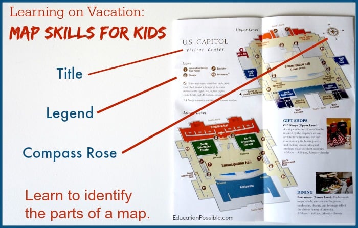
- Map Title – The title of the map will let you know what you are looking at.
- Scale – The scale will help you decipher distance on the map. Understanding if the scale is represented in feet or miles will help determine size and distance.
- Legend/Key – The legend explains the symbols, colors, or patterns found on the map.
- Compass Rose – This will identify the cardinal directions- north, south, east, and west.
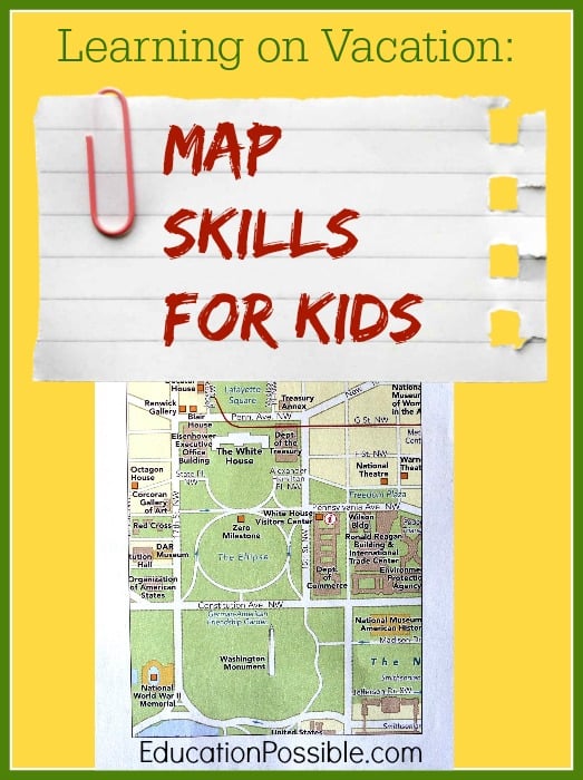
Using Maps During a Trip to Washington, DC
Wondering how to learn on vacation? Here are a few ways we reinforced map skills during our recent trip to Washington DC.
My children love to study United States history, so we supplemented their studies with a visit to our nation’s capital. We would only be there for a few days. It was important to create a game plan to see as many places as possible.
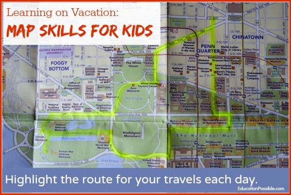
To help us learn more about the many wonderful sites around the city, we purchased a Washington, D.C. Travel Guide that included a road map of the city, with many of the “Points of Interest” clearly marked.
First, the kids identified many of the places they wanted to visit. Then, we used the map to understand where each place was within the city.
Ultimately, they used the road map to decide which direction we could walk to see as many sites as possible.
When we went inside each building, we picked up a map to help us understand how the building was laid out and what we could find on each floor.
Viewing the map of the Capitol Visitor Center, we saw it included details such as elevators, security areas, restaurants, and gift shops.
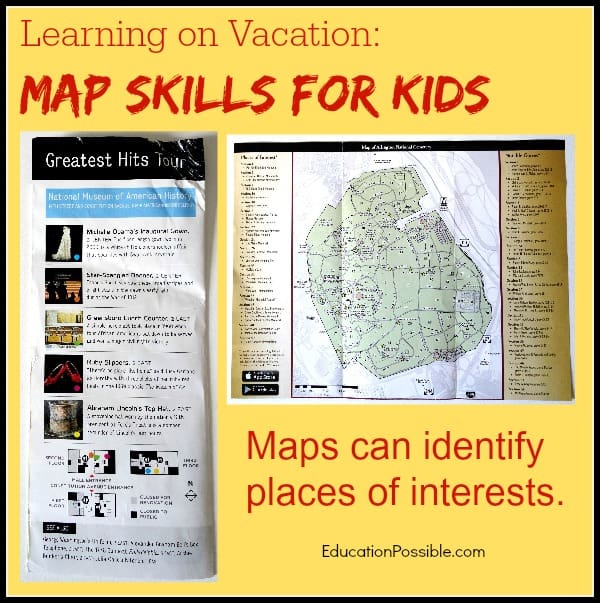
The map of the Smithsonian’s National Museum of American History highlighted some “must-see” exhibits, such as the First Ladies’ Dresses, the Star-Spangled Banner, and the Greensboro Lunch Counter.
The map of Arlington National Cemetery noted many Places of Interest and Notable Graves we could see on our walk through the cemetery.
Tips For Building Map Skills While on Vacation
- Help your children find maps (printed or online) before you leave on vacation. This will help them understand the “lay of the land” before they arrive.
- When looking at a map of the area you are visiting, have kids identify the map’s TITLE, LEGEND, and SCALE.
- Ask tweens to identify two points on the map and determine the best path to travel between the locations.
- Have your children help determine a plan for the day. Using the map, identify the path you will take and the transportation you will use. This is essential to see and do everything on your agenda.
- Document your travels using a map. At the end of each day, highlight the route you traveled and mark the things you did and saw along the way.
We wish you safe and happy travels.
How do you teach your tweens map skills?
7 Comments
Comments are closed.
Thanks for linking up to the Thoughtful Spot Weekly Bloghop!
Anytime we head somewhere new; the zoo, Disney World, etc. I give the kids the map and let them navigate us around. I don’t usually think to get them maps ahead of time though; not sure why since that would be so useful!
We are map geeks, but I haven’t done a lot of formal work with the kids and maps. It is on my plan this fall, but this gives me some great ideas to be adding in along the way. I found this on the finishing strong link up. I am pinning this one.